 Date: 6 February 2011
Location: Silvermine
Walkers: Helen & Michele
*** Route plotted here ***
Yay, back to Silvermine today to explore a path called the Panorama Path (also known as the Skyline Path). We started by heading straight up to and along the gravel road towards Prinskasteel Valley. A westerly wind was blowing and there was some cloud about, but we hoped it wouldn't be a problem. At least it was keeping things nice and cool.

On the way up we saw some colour.


We left the gravel and followed the beautiful stone path down the valley.

Alongside the path we saw Tritoniopsis triticea in bud.

Also plenty of bright magenta vygies.

Constantiaberg was on our right, covered in billowing cloud.

Towards the end of the path it got very sandy. I think the stone gabions are there to stop further erosion.

The Panorama Path started with a turn to the left. It headed straight up the hill, quite steep and rocky.


Beautiful fynbos on this slope. I love the form and colours of both of these.


There were quite a few red ericas. I think this fuzzy one holding all the water droplets is Erica cerinthoides...

... and this smooth but sticky one possibly Erica abietina.

More red Tritoniopsis too, this time with open flowers. I'm curious why its common name is snakeflower.


We also saw a pink Erica, and a very tiny purple flower. I wonder what it is?


The views as we climbed were very rewarding. Hello Hout Bay.

We made our way between the rocks, up and up. Before long Prinskasteel Valley looked far away down below us.


As we neared the top misty cloud began to waft down the valley.

We went over the ridge and followed the path along the other side. The cloud was all around us, but we could just about make out Chapman's Peak Drive and see the sea down to our right.


Suddenly we caught sight of the Sentinel behind the rocky cliff.

Much to our surprise our path began to descend steeply downhill. We could see it heading up again on the other side of the valley. On the map I got the impression this route was more or less on the level, but in fact it went up and down three times. Another one of my maps indicates a dangerous section on this path. We found that although it was steep, it was perfectly manageable, even for me with my fear of heights (although perhaps it would be tricky to navigate in wet or very windy weather).

We saw these on the way down: more geometrical forms in fynbos plants.


Steep uphill again. A group of trail runners that passed us on the down were already half-way up the other side when I took this photo... see them?

As we neared the top again we got another view of Hout Bay.

The path weaved its way through the rocks and restios.


As we got further along we could see Little Lion's Head as well.

To our left we got a glimpse of False Bay.

Directly below us we could see twisty Chapman's Peak Drive.

As we walked over the next ridge we caught sight of Noordhoek's Long Beach. Chapman's Peak was there too, hiding under the cloud.

Once again our path began to head downhill, but not before we saw Noordhoek Peak up ahead. Still a bit of a walk to get there!


Looking behind us we could see the path we'd followed quite clearly. It was a very enjoyable walk...


... and we could see why it is called the Panorama Path (and indeed also the Skyline path). The views were spectacular!

Noordhoek Peak was closer now, an easy climb to reach the cairn.


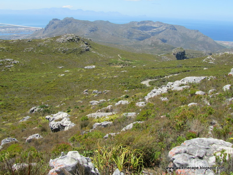
The cloud lifted long enough for us to get a good view of Constantiaberg, and the hills we'd crossed along the Panorama Path.

From Noordhoek Peak we got the classic view of Hout Bay. Glorious!

Some of the flowers we spotted hereabouts: Aristea africana.

Tritoniopsis parviflora.

Penaea mucronata.

We walked down off Noordhoek Peak and joined the gravel road again, heading downhill and back to the dam.

Alongside the road: this yellow bush. Maybe Aspalanthus capitata?


A small and very pretty pelargonium, maybe Pelargonium tabulare?

And funky Stilbe vestita.

We looked for a path to take us from the road to the Amphitheatre Path but took one too soon (I hate it when paths aren't shown in maps - it can be so confusing). The wrong path took us back up the hill, where we had a fabulous view of Silvermine East. We also saw the path we should have been on, so retraced our steps back to the road.
This magnificent dead tree, a kreupelhout I think, was alongside the path.

And hooray, there was our path at last, heading up the ridge. From this route we could see the old dam on the slope below us, with Fish Hoek and Simon's Town in the distance.


Once we reached the Amphitheatre Path we turned right and followed the route all the way down to complete this most enjoyable walk.


.


4 comments:
Some stunning photographs. I recognise many of your wild flowers as garden varieties here in England.
Very interesting !! Enjoyed the walk with you !!
beautiful your descriptions as if I did the hike.. pics fantastic
Thanks for this - going to give it a go
Post a Comment