28 June 2009

Side Note: In Case of Emergency

I've been thinking a lot about safety on the mountain recently. My walking group has been lucky ~ we have never had any incidents, accidents or injuries whilst out walking. Of course, we are careful and use our common sense. For example, we (almost) always :
  • take plenty of water to drink ~ and snacks to eat
  • wear sun hats and plenty of sunscreen (very important in summer!)
  • pack extra layers and waterproof gear (important in all seasons)
  • check the weather report beforehand for expected conditions
  • plan our routes in advance, have a map with us, and stick to paths
  • take charged cellphones, with emergency numbers saved
  • walk in a group, at the pace of our slowest walker
That said, I reckon I could ~ and should ~ do more to be prepared for the worst. A friend had to be rescued off the mountain recently after sustaining serious injuries from a mountain-biking accident (get well soon, Renee!). I've read about climbers being injured or needing rescue several times in the last few months and have also heard of an increase in snake-bites. While walking isn't a particularly high-risk activity, I know an accident could happen at any time.

With this in mind I am focusing on putting together a more comprehensive emergency first aid kit and resolving to carrying it with me at all times. This is going to include the following:
  • headlamp, emergency whistle, space blanket
  • selection of plasters, gauze dressings, and elastic bandages
  • wrist and ankle supports, moleskin for blisters
  • protective gloves, moist towelettes, alcohol swabs
  • painkillers: paracetamol, ibuprofen, aspirin
  • antiseptic ointment, antihistamine
  • Rehydrate sachets
  • cotton swabs, safety pins, tweezers, tissues
  • a page with all my personal info, medial details, emergency contacts and phone numbers for mountain rescue and other emergency services
One can buy first-aid kits, but I like the idea of putting together my own, possibly a full one for my backpack which I take on longer walks, and a second smaller one for the waist-pack I take on short walks. Also, it wouldn't hurt to re-learn some basic first aid. And I will find my pepper spray and keep it handy.

If you have any thoughts on safety I would love to hear them.
.

YUM! Avo and Cheese on Rye


(Photo by Helen)

Avocado pear mashed up and spread onto rye bread, with slivers of cheddar cheese. Mmmm! This is what we snacked on up on the Blackburn Ravine contour path.
.

Blackburn Contour

Date: 28 June 2009

Location: from East Fort on Chapman's Peak Drive, Hout Bay

Walkers: Dorothy, Helen, Tarryn, Paul, Summer

**** Route plotted here ****

As this was a one-way walk we met at the end spot, left a car there, and then headed to our starting point: East Fort near the beginning of Chapman's Peak Drive, Hout Bay.


Our path led up the slope, a steady climb through lovely green fynbos. It was super to see the proteas coming into flower. Metalasia and a lilac-coloured Erica were everywhere too.


Just beautiful!


From our shady hillside we looked across to Chapman's Peak (in the direction we were heading) and Hout Bay harbour (across the bay below). Both were bathed in bright sunshine.


We walked up into Blackburn Ravine. It was quite bushy in the ravine, and the stream was flowing strongly. After a week of rain waterfalls were flowing everywhere!


From Blackburn we continued straight along the contour, through Flat Rock Ravine, and on. It was wonderful walking on the open hillside.


And how nice it was to reach the sunshine finally!


The views continued to take our breath away.


Chapman's Peak Drive looked so far away below us.


Of course we stopped a couple of time for refreshments.


Eventually the path began to descend slowly, to Chapman's Nek and then down to Chapman's Peak Drive and our waiting car.


(Photos by Helen)
.

YUM! Crimson Raisins


(Photo by Helen)

I love raisins, and was delighted to find a new variety... these giant crimson raisins. We ate them, with some walnuts, as a snack in Deer Park.
.

Deer Park

Date: 27 June 2009

Location: Deer Park, on the lower slopes of Devil's Peak, from Tafelberg Rd

Walkers: Dorothy and Helen

**** Route plotted here ****

We'd gone up to Tafelberg Road planning on a walk to the Saddle, but as the wind had come up and the cloud was coming over, we decided to head down instead of up.


So we followed the track down into Deer Park.


After all the recent rain everything was looking wonderfully green and the stream was flowing strongly.


We circled round through the pines and across to the pond.


And then we headed up the slope again. The road was quite steep here. It wound through such beautiful fynbos it felt like we were in a garden. Our very own Table Mountain backyard garden :-)


(Photos by Helen)
.

YUM! French Pastries


(Photo by Helen)

We picked up pain au chocolat and almond croissants from Le Fournil de Plett Bakery. The got a little squished in the backpack but were still absolutely scrumptious when we ate them on the rocks at Kranshoek.
.

27 June 2009

Kranshoek Forest

Date: 19 June 2009

Location: Kranshoek, Harkverville forest, near Plett

Walkers: Helen and Michele

**** Route plotted here ****

We set off from the Kranshoek picnic site, situated a little way inland, and followed the path signposted Kranshoek Coastal Walk.


The path circled round through the pine plantation, and then began to descend through the indigenous forest. Steep log steps all the way down.


Mid-way we got a view across to the opposite site of the valley. The trees mark the picnic site from where we started out. The light was hazy as coastal mist was moving up from the sea.


Here and there we got snippets of the view ahead, through the trees.


Mostly, though, our eyes were down as we negotiated the stairs downhill...


... until, at last, we reached the bottom.


We then followed the steam, crossing across the rocks several times. The forest was simply gorgeous, with the gurgling stream, gentle dappled light and sound of birds twittering away.


So incredibly peaceful!


Then, suddenly, were were out the forest, into some reeds, and onto the beach. As we walked out we disturbed a troop of baboons who were enjoying the sunshine on the rocks. I'm not sure who got the bigger fright! Fortunately they moved off quickly, though we could hear them barking and see them watching us from the cliffs for a while afterwards. I'm terrified of baboons, so didn't enjoy this encounter at all, although I was very grateful baboons in this area are shy and not nearly as cheeky and aggressive as their cousins in the Cape Peninsula.


I loved the beach... so wild and dramatic!


We sat on the rocks, ate our snack and watched the waves pound the rocks.


We walked on a little, following the path over rocks, until we came to a signboard. Instead of continuing along the coastal path we elected to head straight up. This shorter route went up the cliff, to the view site on top.


Into the forest we went again, the path zig-zagging steeply uphill. At every opportunity we turned round for views back to the coast.


We watched the shifts as we changed elevation.


At the top we headed out on the path back to the picnic spot.


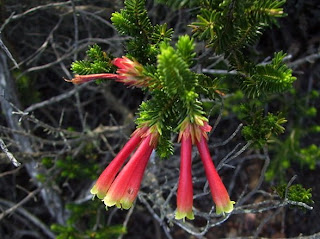
There was quite a lot of familiar fynbos along this cliff-top track, with a few things in flower.


The mist had moved right up into the valley. There wasn't much water flowing over the waterfall at the top.


The beach where we'd sat earlier looked so far away!


After a rest at the picnic site we then strolled along the Forest Flora Trail, a kilometre-long circular route through the forest. There's a wide variety of trees here, and many are labelled or numbered. Info sheets are available at the start, so this is a great place to learn your trees, if that's your thing.


(Photos by Michele and Helen)
.