Date:
Date: 17 July 2010
Location: SilvermineWalkers: Helen and Dorothy
***
Route plotted here ***
I've been walking in the Silvermine area a lot this winter. Not only is it a beautiful place with lots of different routes to explore, but it's one of the few areas I feel okay about walking in when there are just two or three of us (and no dogs). Of course I can't say for sure it is safe but I haven't heard of any incidents there recently. This particular morning we were meant to be a bigger group, but as it happened it was just me and Dorothy who able to make it. So off we went!

We crossed the dam wall and headed up the main gravel jeep track.


I'd planned our route before we started and according to the map we were to take a path to our left when the jeep track did a right. The first path we took, right on the corner, petered out very soon - it seemed to lead to a small rocky outcrop close to the road and not beyond. So we backtracked and just a short way further we saw a second left off the jeep track. There was a 'no mountain bikes' sign at the start and it was a much more distinct path than the first one. Yes, this was the correct path.


It lead off across the Steenberg Plateau, descending very gently. The mountains above St James and Kalk Bay (Silvermine East) were clearly visible in the distance.

And we could see Fish Hoek and Simon's Town down to our right.

After a very rainy week there was a lot of moisture around. In several places streams ran in the path. The stepping stones were very useful!


Along here we spotted the swamp daisy, Osmitopsis asteriscoides. Isn't it gorgeous?! There is a Swamp Daisy Valley in Silvermine, not far from where we were walking... I think I need to do some exploring there.

This reedy plant beside the path was full of droplets of water. They looked like diamonds in the sunshine.

It was turning out to be a lovely day, with the odd cloud floating by.

When we came to an intersection we turned right, walked on for a bit and then took a left. The plan was now to complete a circular route past the small peak of Bokkop which would bring us back to this spot later on.


The path continued downwards. On this stretch we saw some wonderful fynbos. Lots of creamy metalasia and lemon-yellow leucadendron.

There were also several large mimetes and protea bushes on the slope. I think these ones are Protea lepidocarpodendron and Mimetes fimbriifolius.


Berzlia lanuginosa. Soon these buds will open into fluffy white pompoms.

Stilbe vestita I think. Love the form!

And the delicious-smelling Cape Sweetpea, Podalyria calyptrata.

This pretty shrub had soft grey foliage and delicate purpley-pink flowers. Help, I have no idea what it is!


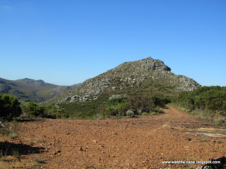
Bokkop was to our right. A cloud was casting a shadow on the peak.

Our path ended on a jeep track. We turned right and followed the track up to and past the front of Bokkop.


The lower slopes were covered in restio and metalasia bushes.

And an endless range of textures and colours in the vegetation.


A bird of pray was soaring above. I remember seeing the same last time I walked past Bokkop.

We continued on, past the peak...

... until we came to a perfect spot for a snack stop. The jeep track continued on behind us - this route is the
Old Wagon Path which lead down to Ou Kaapse Weg.

Our path, though, was the one that went straight. It climbed steadily, and circled round to the right. After a while we passed the paths we'd walked on earlier and continued straight up the hill.


More proteas were growing here, this one Protea repens.

We took a path to the left again, heading across the sandy plateau.


The path headed towards and to the right of a small peak. From here we got great views down to False Bay.


Over the rise we rejoined the original jeep track and completed our figure of eight route. Now, back down towards the dam.


Beautiful pink erica was growing in abundance alongside the path.

Every shade of pink!


I love this dam: perfect cloud reflections on a perfect still winter's day.

.
 Date: 20 July 2010