Lists of Walks
▼
28 February 2009
Fish Hoek Beach
Date: 28 February 2009
Location: Fish Hoek beach
Walkers: Helen, Ian and Dominic, with dogs
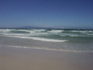
We set off intending to swim, but the wind was blowing so strongly and the water was so cold we decided it was not swimming weather.
Instead we had a walk up and back along the kelp-strewn beach, which the dogs enjoyed very much.
The beach stretches between Clovelly corner, with Trappies Kop above, towards Fish Hoek on the slopes of Elsies Peak.
(Photos by Helen)
Table Mountain: Kloof Corner
Date: 25 Feb 2009
Location: Kloof Corner, off Tafelberg
Road, Table Mountain
Walkers: Helen and Delphi
This route is another one of our favourite easily-accessible after-work walks.
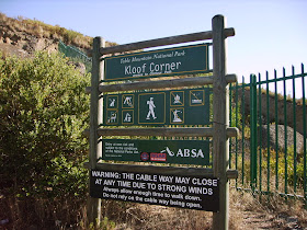
Tafelberg Road winds up from Kloof Nek. On the last big bend, a little way before the lower cable station, a signboard showed the start of this walk.
The path, stone steps to start and later log steps, headed straight up.
It has been extremely hot, dry and windy for the last few weeks, with many fires all over the Cape. The fynbos on these slopes looked brown and parched, as if any flame could set off a burn.
The path zig-zagged up the slope, with a last sharp climb up more stone steps to the base of the rocky cliff, and some shade.
From here we looked across Kloof Nek to Lion's Head and also peeked around the corner to the Twelve Apostles.
We then followed the contour path that runs at the base of the cliff across the face of Table Mountain.
After a short while we were below the cableway.
We could see the upper cable station at the very top of Table Mountain. We turned down and headed back, past the lower cable station, and along the road back to the start.
(Photos by Helen)
24 February 2009
Beta Road Beach
Date: 22 February 2009
After this walk some of us needed a swim. So we stopped in at Beta Road Beach at Bakoven (near Camps Bay) for a dip in the Atlantic. The water was cold, but so refreshing!
(Photos by Michele)
23 February 2009
Hout Bay Contour
Date: 22 February 2009
Location: Hout Bay
Walkers: Dorothy, Michele & Brenda (pictured left) and Helen, Jenny & Iain
This route started just off Hout Bay Nek (a.k.a. "Suikerbossie" Hill) and followed the contour path along the back end of the Twelve Apostles in the direction Constantia.
The walk began with a short climb up logged steps under some pines to get to the contour path.
(Photos by Helen)
We gathered to catch our breath and appreciate the view west.
(Photo by Helen)
From here we looked across to Little Lion's Head and Llandudno.
(Photo by Michele)
Then we turned towards the mountain behind us: Geelklip Buttress, the southern face of the Twelve Apostle range of peaks.
(Photo by Michele)
As we walked along the contour path this mountain was on our left.
(Photos by Michele)
It was very easy walking, mostly flat, with the fynbos particularly lovely in the early morning sunshine.
(Photo by Helen)
The March lilies were out!
(Photo by Michele)
There were a few other flowers to be seen here and there as well.
(Photos by Michele) (Photos by Helen)
The whole of Hout Bay was spread out below us. Magnificent!
(Photo by Michele)
As we got further our view was across to Vlakkenberg.
(Photo by Michele)
And a little further on we could see Constantia Corner too.
(Photo by Michele)
The path now headed into some dense indigenous forest and climbed steeply through the tangled trees. This was Myburgh Waterfall Ravine.
(Photos by Michele)
We climbed until we reached the waterfall. There was just a soothing trickle of water flowing over the mossy surface.
(Photos by Michele)
We spotted some Red Disas high up the cliff. Thanks Iain for climbing up to get this shot below.
(Photo by Iain)
After our picnic stop at the waterfall we retraced our steps. Once out the forest we looked up to Myburgh's Corner and Myburgh's Waterfall Ravine from below. I'm very keen to walk further up there one day soon.
(Photo by Michele)
On the way back we stopped to admire the views.
(Photo by Michele)
Soon we were at the end of this lovely walk.
(Photo by Michele) (Photo by Helen)
See Postscript (to be published tomorrow) : our swim after this walk
Location: Hout Bay
Walkers: Dorothy, Michele & Brenda (pictured left) and Helen, Jenny & Iain
This route started just off Hout Bay Nek (a.k.a. "Suikerbossie" Hill) and followed the contour path along the back end of the Twelve Apostles in the direction Constantia.
The walk began with a short climb up logged steps under some pines to get to the contour path.
(Photos by Helen)
We gathered to catch our breath and appreciate the view west.
(Photo by Helen)
From here we looked across to Little Lion's Head and Llandudno.
(Photo by Michele)
Then we turned towards the mountain behind us: Geelklip Buttress, the southern face of the Twelve Apostle range of peaks.
(Photo by Michele)
As we walked along the contour path this mountain was on our left.
(Photos by Michele)
It was very easy walking, mostly flat, with the fynbos particularly lovely in the early morning sunshine.
(Photo by Helen)
The March lilies were out!
(Photo by Michele)
There were a few other flowers to be seen here and there as well.
(Photos by Michele) (Photos by Helen)
The whole of Hout Bay was spread out below us. Magnificent!
(Photo by Michele)
As we got further our view was across to Vlakkenberg.
(Photo by Michele)
And a little further on we could see Constantia Corner too.
(Photo by Michele)
The path now headed into some dense indigenous forest and climbed steeply through the tangled trees. This was Myburgh Waterfall Ravine.
(Photos by Michele)
We climbed until we reached the waterfall. There was just a soothing trickle of water flowing over the mossy surface.
(Photos by Michele)
We spotted some Red Disas high up the cliff. Thanks Iain for climbing up to get this shot below.
(Photo by Iain)
After our picnic stop at the waterfall we retraced our steps. Once out the forest we looked up to Myburgh's Corner and Myburgh's Waterfall Ravine from below. I'm very keen to walk further up there one day soon.
(Photo by Michele)
On the way back we stopped to admire the views.
(Photo by Michele)
Soon we were at the end of this lovely walk.
(Photo by Michele) (Photo by Helen)
See Postscript (to be published tomorrow) : our swim after this walk